Folder-based processing
Start with photos, videos or mixed media stored in ordinary project folders.
AI-assisted field data triage
TrailEye AI helps researchers and conservation teams triage photos and videos, inspect predictions, recover timestamps, explore activity patterns and export findings from a Windows desktop workflow.
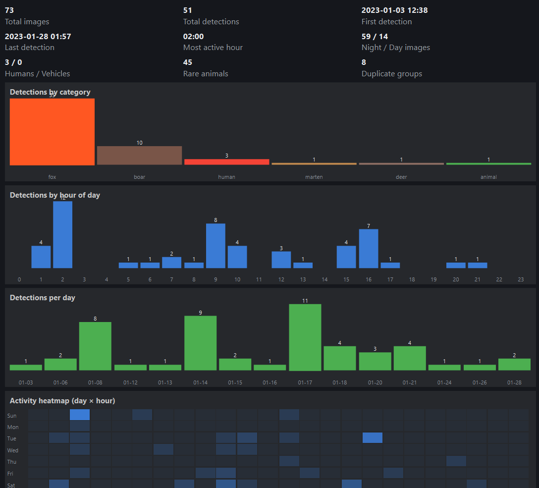
Activity views remain connected to reviewable detections. AI output is an aid to triage, not a substitute for project validation.
A cohesive desktop workflow
TrailEye combines steps that are often split between scripts, spreadsheets, media viewers and mapping tools.
Start with photos, videos or mixed media stored in ordinary project folders.
Surface likely animal, person and vehicle events before detailed human review.
Refine animal detections into a supported-species library where the model has sufficient evidence.
Confirm, reject and relabel predictions so uncertain output is not silently treated as truth.
Use OCR, EXIF and file-time fallbacks plus camera-site mapping to restore field context.
Produce CSV, Excel, selected images and PDF reports for downstream work and communication.
Camera-trap images vary by habitat, geography, season, camera model, illumination and animal distance. A species model that performs well on one project may behave differently on another. TrailEye therefore keeps predictions reviewable and supports correction rather than presenting automation as expert certainty.
Before operational use, evaluate detection recall and species precision on a representative, permissioned sample from your own deployment. Retain a human verification step for project-critical records and document the software version, model, settings and review protocol used.
Camera-trap datasets can reveal endangered-species locations, private land, personnel movements and bystanders. TrailEye’s standard detector runs locally on the Windows computer and does not require the archive to be placed in a hosted gallery. This can help teams working with limited connectivity or data-governance constraints.
Some functions may still use a network connection: maps can load online tiles, licence operations may contact the licensing service, and an optional cloud text-prompt search sends selected images to a provider chosen by the user. Projects requiring strict offline operation should assess and disable network-dependent features.
Trail cameras frequently burn date and time into image pixels, and metadata may be absent or unreliable. TrailEye can apply OCR to the visible overlay, then use EXIF or file time as fallbacks. The recovered timestamp and confidence should be reviewed where timing affects analysis.
After review, TrailEye can summarize observations by species, hour and day and provide heatmaps, sun-period and moon context. Camera sites can be placed manually or derived from photo GPS where available. These views support exploration; researchers should conduct formal statistical analysis in an appropriate downstream environment.
Professional removes workflow limits but does not turn AI predictions into validated biological labels. Project-level validation remains essential.
Related TrailEye workflows
Free edition · Full AI recognition · Human review remains essential